UPDATES

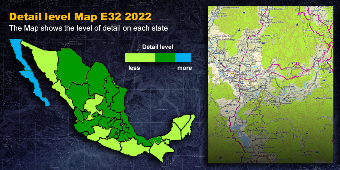
THE MAP SHOWS THE LEVEL OF DETAIL ON EACH STATE
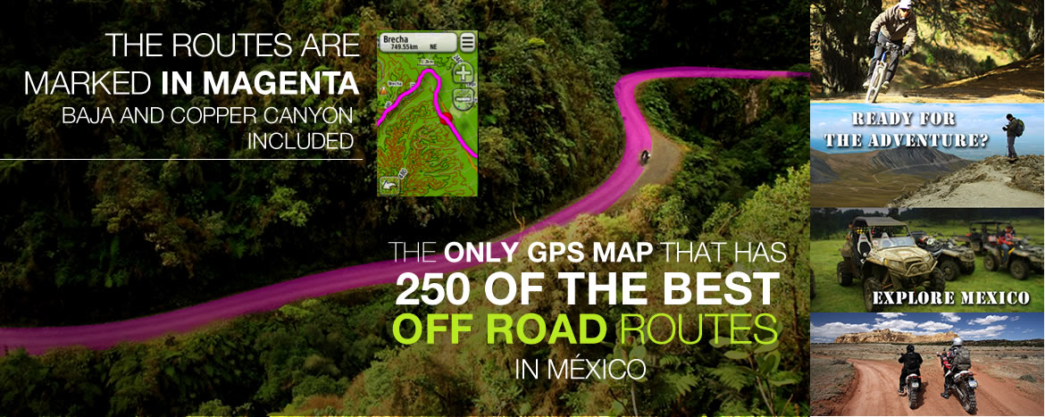
The Map E32 now has 300 ROUTES for OFF ROAD, mountain Biking, and Trekking
All the Highways of Mexico were updated
In a great part of Mexico the following changes were made:
Chihuahua, 75% of Tamaulipas and Tabasco, had the following changes:
The Map E32 now has 300 ROUTES for OFF ROAD, mountain Biking, and Trekking
All the Highways of Mexico were updated
In a great part of Mexico the following changes were made:
The North of Chihuahua, Tamaulipas, Puebla, Tlaxcala and The South of San Luis Potosi, had the following changes:
The Map E32 now has 300 ROUTES for OFF ROAD, mountain Biking, and Trekking
All the Highways of Mexico were updated
In a great part of Mexico
the following changes were made:
Nayarit, Cohahuila, Tlaxcala, Morelos, the South part of Puebla and the North part of San Luis Potosi, had the following changes:
The Map E32 now has 300 ROUTES for OFF ROAD, mountain Biking, and Trekking
All the Highways of Mexico were updated
In a great part of Mexico
the following changes were made:
North Baja and South Baja now have more detail (no other map has this kind of detail) Jalisco, Puebla, Coahuila, Aguascalientes and Colima were also updated.
The Map E32 now has 300 ROUTES for OFF ROAD, mountain Biking, and Trekking
All the Highways of Mexico were updated
In a great part of Mexico
the following changes were made:
North Baja and South Baja now have more detail (no other map has this kind of detail) Nuevo Leon, Puebla, and Coahuila also were updated.
The Map E32 now has 280 ROUTES for OFF ROAD, mountain Biking, and Trekking.
All the Highways of Mexico were updated
In a great part of Mexico
the following changes were made:
The states of North Baja, South
Baja, Jalisco, Veracruz, Estado de Mexico, Guanajuato, Queretaro and
50% of Nuevo Leon
now have more detail:
The Map E32 now has 250 ROUTES for OFF ROAD, mountain Biking, and Trekking.
All the Highways of Mexico were updated
In a great part of Mexico
the following changes were made:
The states of Zacatecas,
Tabasco, Guerrero, Campeche and Quintana Roo
had the following changes:
North Baja, South Baja, Part of Jalisco, Federal
District and Morelos
now have more detail:
Map E32 2016 presentation
We added 30 ROUTES for OFF ROAD, mountain Biking, and Trekking.
In a great part of Mexico the following changes were made:
The states of Sonora,
Tamaulipas, Chiapas and the area of Copper Canyon in
Chihuahua
had the following changes:
We added around 100 of the Best OFF ROAD ROUTES in Mexico.
We added around 10,000 gas stations in all Mexico.
We added around
500,000 points of interest throughout Mexico such as hotels,
restaurants, etc.
In a great part of Mexico the following changes were made:
The states of Sinaloa, Oaxaca
and southern part of Chihuahua
had the following changes:
North and South Baja
now have more detail:
Great part of México had the following changes:
Durango, San Luis Potosi, Hidalgo and 60% of
Chihuahua
Had the following changes:
*A new polygon was added for the snow areas.
CAMPECHE and CHIAPAS
Had the following changes:
Distrito Federal, Guanajuato, 70% of Guerrero,
Estado de México, Michoacán, Morelos, Nayarit, Puebla, Tlaxcala and
Veracruz
Had the following changes:
*An extra level was added, so that a high zoom level, only state lines, oceans, roads, state names and capitals are visible.
DURANGO, ESTADO DE MEXICO, GUERRERO, MICHOACAN,
OAXACA, PUEBLA, QUINTANA ROO, TLAXCALA, TABASCO, YUCATAN AND
ZACATECAS.
Had the following changes:
COAHUILA, JALISCO Y YUCATAN
Had the following changes:
- OVER 80% OF NUEVO LEÓN Y QUERÉTARO'S GAPS AND TRAILS WERE TRACED.
- THE MAP GREW FROM 240 MB TO 800 MB APROXIMATELY.
CHIHUAHUA, COAHUILA, HIDALGO,
MORELOS, SAN LUIS POTOSI, SONORA Y VERACRUZ
had the following changes:
The states of: Aguascalientes, Baja California,
Baja California Sur, Colima, D.F., Guanajuato, Jalisco, Nayarit,
Nuevo León, Queretaro, Sinaloa, Tamaulipas
had the following changes:
At national level, all 32 states had the following changes:
INCREDIBLE DETAIL, 5 STATES WERE PRIVILEGED... THERE'S NO MAP ON THE MARKET THAT CAN COMPARE!
Over 80% of gaps and trails were traced in the following states:
- The map contains over 250 cities with street and avenue names.
INCLUDED CITIES:
- The 32 state capitals
- Some of the other most important cities
- Every city in the following states:
- 100,000 paths for dirt roads and trails in the
country were added.
- The search function for streets and crossroads was enabled for all
Garmin GPS devices.
- Search for addresses or crossroads from the 250 cities by entering
data such as STATE / CITY / STREET
and the screen shows were the street is located.
- Every state is an individual map.
- Dirt road visualization was improved.
- The map contains over 250 cities with street and avenue names.
INCLUDED CITIES:
- The 32 state capitals
- Some of the other most important cities
- Every city in the following states:
- 100,000 paths for gaps and trails in the country
were added.
- The search function for streets and crossroads was enabled for all
Garmin GPS devices.
- Search for addresses or crossroads from the 250 cities by entering
data such as STATE / CITY / STREET
and the screen shows were the street is located.
- Every state is an individual map.
- Dirt road visualization was improved.